Posts

Showing posts with the label Streetcar

Why Right Rail is Wrong, and Right
Image
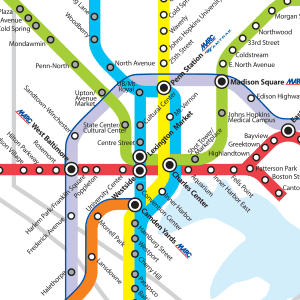
The Shoulda, Woulda, Coulda of the Red Line: Part of 2002 transit plan When the Red Line was first proposed in 2002 the decision on the exact route and transportation mode were far from certain. We all know what decision was eventually made, but direction the line took could have turned out much different. A definite missed opportunity was not pursuing a heavy rail option and thinking of the current metro subway as a trunk line that a spur line could split off from. With this in mind the Red Line planners could have built a spur using the a Route 40 ROW - which the current plan calls for - from West Baltimore MARC with stops in Harlem Park and UMB, before turning south and connecting with the metro subway at Lexington Market. Here a proper transportation hub and transfer point could have been built as intended. The line would have allowed for a direct connection to downtown and Johns Hopkins Hospital while using available infrastructure. A small spur, with high capacity, for m...

Using Existing Infrastructure to Build a Streetcar

For the past several years, there has been a push to put a streetcar along Charles Street, but let's just say there has been some resistance from some of the communities along Charles Street who feel that it will cause more trouble than good. I am definitely in favor of creating a new streetcar line in Baltimore, but I am not fully sold on the route that is currently being proposed by the Baltimore Streetcar Campaign. The proposed route goes up starts at the Inner Harbor, goes north on Calvert, turns west on Redwood, and then north on Charles until University Parkway, where it loops and turns south on St. Paul Street. It then turns west on Mt Royal and then South on Maryland Ave/Cathedral Street/Liberty Street/Hopkins Place/Sharp Street turns east on Conway and then north on Light Street back to the Inner Harbor. In my opinion there are two issues with this route: 1.) Charles Street is narrow and congested through Mount Vernon until past Penn Station; and 2.) the route on the s...

Portland, Where the Streetcar Works

Image
On my current work-related road trip, I find myself in Portland, Oregon, where transit, especially light rail and streetcar, seems to work really well. So well, in fact, in addition to the three current light rail lines and the Portland Streetcar, a fourth light rail is under construction right now with a fifth and additional streetcar line in the early planning stages. Meanwhile, in Baltimore, we have been struggling for the past seven years to implement one light rail line. The centerpiece of Portland's success is their streetcar loop. The four mile line (nearly 8 mile roundtrip loop) connects the Northwest, Pearl, Downtown, University, and Waterfront districts, and picks up around 10,000 people daily. The best feature is for most of the ride it's free. As a streetcar the cars move with traffic at the normal speed limit. There are fixed stops every couple blocks making it more like light rail than a traditional streetcar which would stop at any block a passenger desired. Like...