Posts

Showing posts from 2014

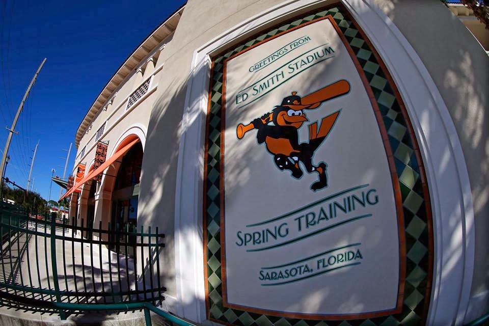
Big Improvements to Light Rail that Would Make For a Better System

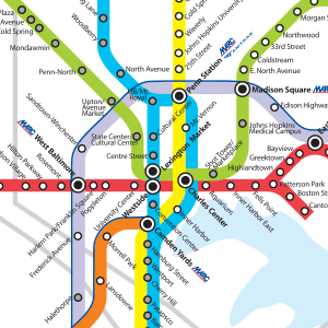
In the long term planning, the MTA wants to extend the Light Rail (dubbed the Yellow Line) passed BWI all the way to Columbia, connecting the BWI Rail Station and Dorsey MARC station along the way. I honestly do not think extending the route to Columbia is the best choice. Instead how about extending just to Dorsey. The spur from BWI Business District to the international terminal should be abandoned and This ROW used for a people mover that would connect the parking garages, long term parking, and the terminal with the light rail station.  Adding infill stations along the route the current route would allow for better access to more communities. The station platforms at Texas are already there; a new park-and-ride station can be added here pretty easily. Walk-up stations should be considered at Ruxton along Bellona Avenue and Remington/Hampden at Wyman Park Drive  to access neighborhoods that are currently bypassed. This last station could provide better access to Druid Hill Park

Could the Four Seasons Condos Finally be on the Way?

Image
Tower crane going up alongside the Four Seaons Hotel in Harbor East. Could the long awaited condos finally be on the way, or just more hotel rooms? In any case the revised plan only puts the building at a few more floors, or only as tall as the Legg Mason Building next door. 

Why Right Rail is Wrong, and Right

Image
The Shoulda, Woulda, Coulda of the Red Line: Part of 2002 transit plan When the Red Line was first proposed in 2002 the decision on the exact route and transportation mode were far from certain. We all know what decision was eventually made, but direction the line took could have turned out much different. A definite missed opportunity was not pursuing a heavy rail option and thinking of the current metro subway as a trunk line that a spur line could split off from. With this in mind the Red Line planners could have built a spur using the a Route 40 ROW - which the current plan calls for - from West Baltimore MARC with stops in Harlem Park and UMB, before turning south and connecting with the metro subway at Lexington Market. Here a proper transportation hub and transfer point could have been built as intended. The line would have allowed for a direct connection to downtown and Johns Hopkins Hospital while using available infrastructure. A small spur, with high capacity, for m

Chesapeake Shakespeare Company

Image
New sign along S. Calvert Street. New sign is up at the future home of the Chesapeake Shakespeare Company at 7 S. Calvert Street (historically 202 E. Redwood Street) originally built in 1885 for the Mercantile Trust and Deposit Company.  as the home of the  Mercantile Trust and Deposit Company, ca. 1958

Rethinking the Camden Line, Phase I

Image
2002 Baltimore Rail Plan The 2002 Baltimore Rail Plan, besides planning for brand new routes, also envisioned expansion and reimagining of current routes. One of which was the Camden Line. The 2002 plan proposed expanding service to include local, more frequent service between Dorsey and Camden Station, in addition to the current commuter service to Union Station. While the plan did not go into very much detail it did include infill stations, and presumably "light rail" style frequencies. As things go, this never made it past the drawing board as the Red Line got the priority and maybe the Green Line extension next. This doesn't mean we shouldn't think about how to better use the Camden Line. In fact, with the infrastructure already there it really is a good option to provide better transit service to Baltimore. So let's say there is both funding and the full cooperation of CSX, with that in mind let me propose that we do exactly what the 2002 plan recommen

Street Collapse on 26th St

Image
photo by Baltimore Business Journal Collapse of section of 26th Street between St. Paul and N. Charles spilling mud, debris, and cars down on to the CSX (old B&O Belt Line) tracks in Charles Village. The Jones Falls has also flooded in Mt Washington and along Falls Rd near Penn Station and the Streetcar Museum.

Small Improvements to Light Rail That Could Make a Big Impact

Image
S equence lights on Howard Street so trains can move between stations without having to stop at red lights. This would significantly cut down on the travel time between Mt. Royal/UB and Camden Yards. The technology is there, it just needs to be implemented in a more sensible way.  Improve passenger information at each station. This would include updating the maps to reflect the current light rail operation. The maps at most stations outside of downtown are poorly designed and show the light rail configuration when the extensions to Penn Station and BWI first opened in 1997. Way-finding and neighborhood maps showing immediate transit connections and local attractions are a must. Posted schedules should be updated immediately whenever a new version of the timetable is made. Newer Light Rail map at downtown stations. Update signs at all stations. A few years back the downtown stations had new signs that replaced the originals from 1992. In addition the stations feature a system

Check the Flag Code, Baltimore

Image
photo by blogger Things are moving along at the apartment renovation at 301 N. Charles Street. The developers even added two new flags to the poles that have stood devoid of ensigns for far too long. Except there is just one little problem, they flags are one the wrong poles! If I remember one thing from the flag etiquette it's that the US flag is always to the left when hanging from a building when there are two poles. It's the same rule the the flag is always to the right of a speaker when on the stage (that is, the left of the stage when viewing from the audience). The other helpful giveaway on this particular building (and we have the state of Maryland to thank for this) is the finial on the right hand flag pole is in the shape of a bottony cross; which denotes that this is the pole that the Maryland state flag is supposed to fly from. Really, it's not that complicated. I will now step down from my soapbox rostrum.

Spring Training!

Image
Hopefully this picture will help everyone get over the Winter Blues. Spring Training is in full force down in Sarasota. Baseball will be at Camden Yards in no time!

Then and Now: Loyola University Maryland

Image
Loyola University Maryland, for the longest time known as Loyola College, was founded in 1852 and moved to it's present North Baltimore campus in 1921. The view of the corner of N. Charles Street and Cold Spring Lane has changed a lot over 93 years, just take a look at the signage on the corner.  circa 1920s 2006 2009 2014